The Arbor closure
The Arbor is currently closed today (26 April) but will be open as normal on Monday 29 April. We are very sorry for any inconvenience this may cause.
Natural Flood Management (NFM) is a term used to describe working with natural processes to reduce flood risk. NFM will not resolve all flooding issues but are part of the overall solution to reducing flood risk.
There is no ‘one size fits all’ approach to natural flood management and it’s about using a range of measures that work with the landscape, from creating ponds and woody dams to redirecting and reprofiling river channels, that work together to reduce flood risk.
Gloucester City Council has secured £80k to carry out Natural Flood Management works as part of a government funded competition to help protect homes and businesses, the first of its kind to fund innovative projects that use landscape features and trees to store, drain or slow flood water creating habitat and reducing flood risk.
Natural flood management already forms an important part of the government’s flood strategy and funding new projects builds on £14m already committed to similar schemes across the country.
Gloucester City Council was one of 34 community led projects which were allocated funding from a £1m government fund to explore the different ways these approaches can benefit communities and the environment.
Download a list and map of natural flood management schemes.
Gloucestershire Wildlife Trust (GWT) is carrying out the works on behalf of the City Council on the Upper catchment of the River Twyver at Upton St. Leonards in Stroud.
GWT is also engaging with and advising landowners on potential works and have installed 10 large Leaky Dams to date. The works are likely to incorporate a number of measures including:
The project is also receiving ongoing support from Stroud District Council and the Environment Agency.
The aim of this project is to reduce the downstream peak flows during a storm event or flooding and to reduce the silt loading during these events.
By restricting the progress of water through a catchment will make the catchment rougher and more difficult for water to flow quickly over land and in stream. The phrases "Slow the flow" or "Working with natural processes" are sometimes used to describe this approach to reducing flood risk which relies on one, or a combination, of the following underlying mechanisms:
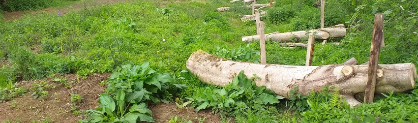
Large woody debris to help slow down the rate at which peak flows travel downstream and to spread the peak over a longer time period.
The Land Drainage Act requires owners of land next to watercourses to maintain and remove obstructions to flow and historically, wood and fallen trees have been removed from streams and watercourses. Whilst managing banks and removing obstructions can be essential to reduce flood risk in some locations, there are places where leaving trees or adding woody debris dams can be beneficial.
Wood debris dams form naturally when large and long sections of tree fall into and across the channel. These large sections start to gather smaller sticks and leaves which provide a permeable surface that allows water through, but crucially, reduces the rate of flow of water in the stream during high flows. Research has demonstrated that both small and large woody debris are essential for a healthy, functioning watercourse.
Woody debris changes the physical shape of the channel and can push flows out of the channel onto the bank. It helps to create pools and riffles, providing a variety of habitats for fish and aquatic insects and attracting mammals and birds. Importantly for our purposes, large woody debris can also slow the movement of silt and sediment downstream.
Large woody debris slows the rate at which a flood peak travels downstream by providing a physical barrier to flows. A large number of debris dams in a short stretch of stream can be more effective than a single large structure. Large Woody Debris can help to store and attenuate water. This is particularly the case when water is pushed out of channel and onto the flood plain.
The presence of woodlands and hedgerows can significantly reduce peak water flows through several mechanisms including increased evaporation loses (particularly after canopy interception), increased water storage capacity of soils under tree cover, increased water infiltration potential, and decreased soil bulk density from the influence of root growth.
The provision of hedges and woodlands on farms can increase the delivery of ecosystem services, both directly and indirectly. Hedges and woodland patches can increase the potential for carbon capture and storage in woody biomass, and via the improvement of water infiltration rates to soil, reducing the potential for flooding. In addition hedgerows and woodland increase the habitat resource availability for essential wildlife, including species that undertake pollination or act as natural controllers of other pest species.
The project is focusing on sustainable and long term solutions to reducing flood risk and evaluating the overall benefits of Natural Flood Management measures as part of the solution.
A number of methods will be used to evaluate the effectiveness of the project including fixed point photography, ecological and habitat surveys and the use of existing telemetry to measure water depth of the River Twyver downstream of the works during heavy rainfall and storm events.